Places to go and things to see by Gypsy Bev

Posts tagged ‘Washington’

Cambridge Ohio Union Depot – Then and Now

Early Cambridge Union Staton - 1907

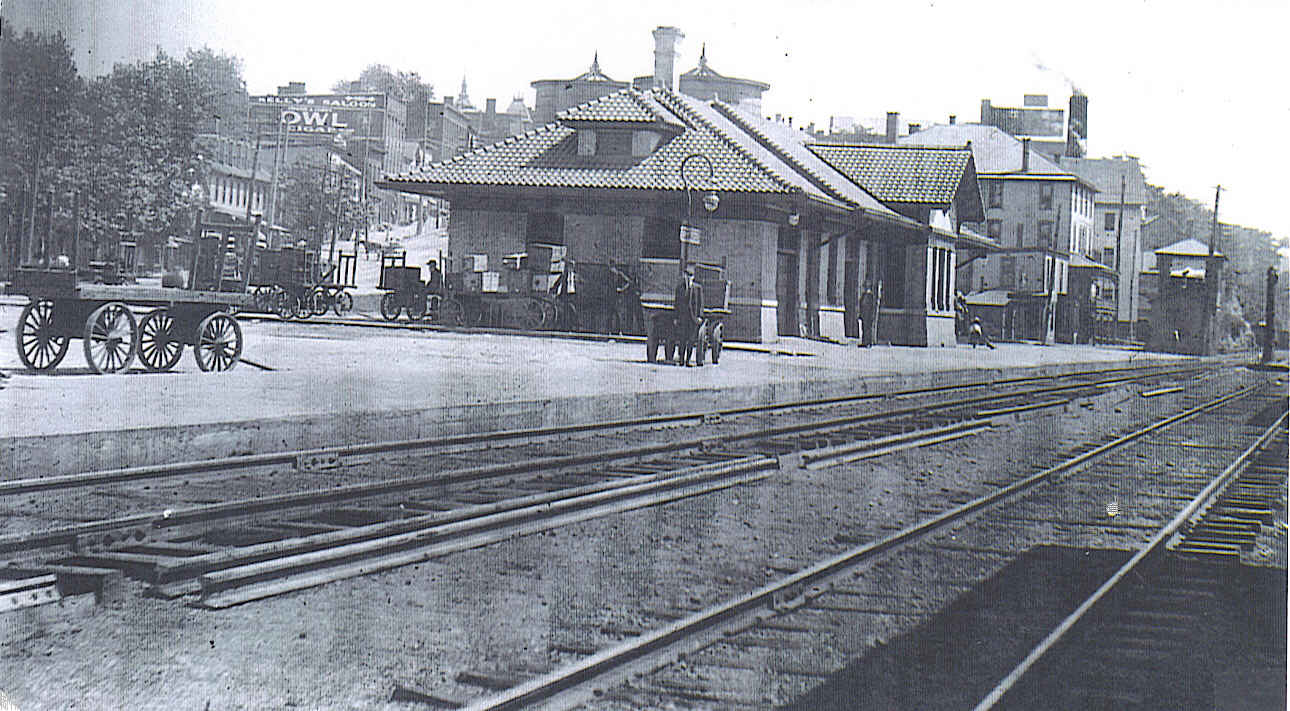
Early Cambridge Union Staton – 1907

Long ago the railroad station at Cambridge, Ohio was a hub of activity. Originally, the Baltimore & Ohio Depot was located on the first floor of the Depot Hotel at 444 Wheeling Avenue. However, the most recent railroad station, Cambridge Union Station, was built by the B & O and Pennsylvania Railroads in 1907. According to local train historian, Dave Adair, this special railroad station had an identical twin built by B&O Railroad at Washington, Indiana. Today Cambridge Union Station remains along the tracks, but stops are no longer made there…only memories remain.

Deliveries of mail and goods were made at the train depot around the clock for fifty-four years. Mail was placed in a mail cart, then pulled by mule up the hill to the post office, which was then located where Pavlov’s Music is today. Orders placed at Sears or Montgomery Ward were usually delivered the next day, and often residents would eagerly wait by the tracks for their arrival. For those who could not meet the train, delivery services, like those run by Billy Singer, met the train daily for home deliveries.

Imagine the thrill of a memorable school field trip on the train. Such was the case with first grade students from Glass Plant School, who enjoyed riding the rails to New Concord. There they visited the home of their teacher, Miss Daniels, enjoying milk and cookies along with a view of her flower garden. Before the return trip to school, a walking tour of Muskingum College campus impressed the youngsters.

Memorial Plaque at Cambridge Union Depot

Memorial Plaque at Cambridge Union Depot

My family would drive to town in their pick-up truck to get cardboard cartons of baby chicks that arrived on the train. Mom always went along to stop at Thompson Feed Mill for feed for the chickens. She wanted to be sure to get feed sacks that would match the ones she was using to make some kitchen curtains or pillowcases.

Those were the days when people used the train instead of an automobile for trips to far off Zanesville and even Columbus. A friend recalled  the thrill of riding the rails to Zanesville to visit her eye doctor. Another remembered trips to Lazarus in Columbus via the train as a family adventure.

Dad often talked of hopping on the train to Chicago. Back in 1958, the cost of a one way ticket was $19.85, which included an overnight Pullman car. Have to wonder if in his younger days, Dad rode in the Pullman or perhaps in a boxcar?

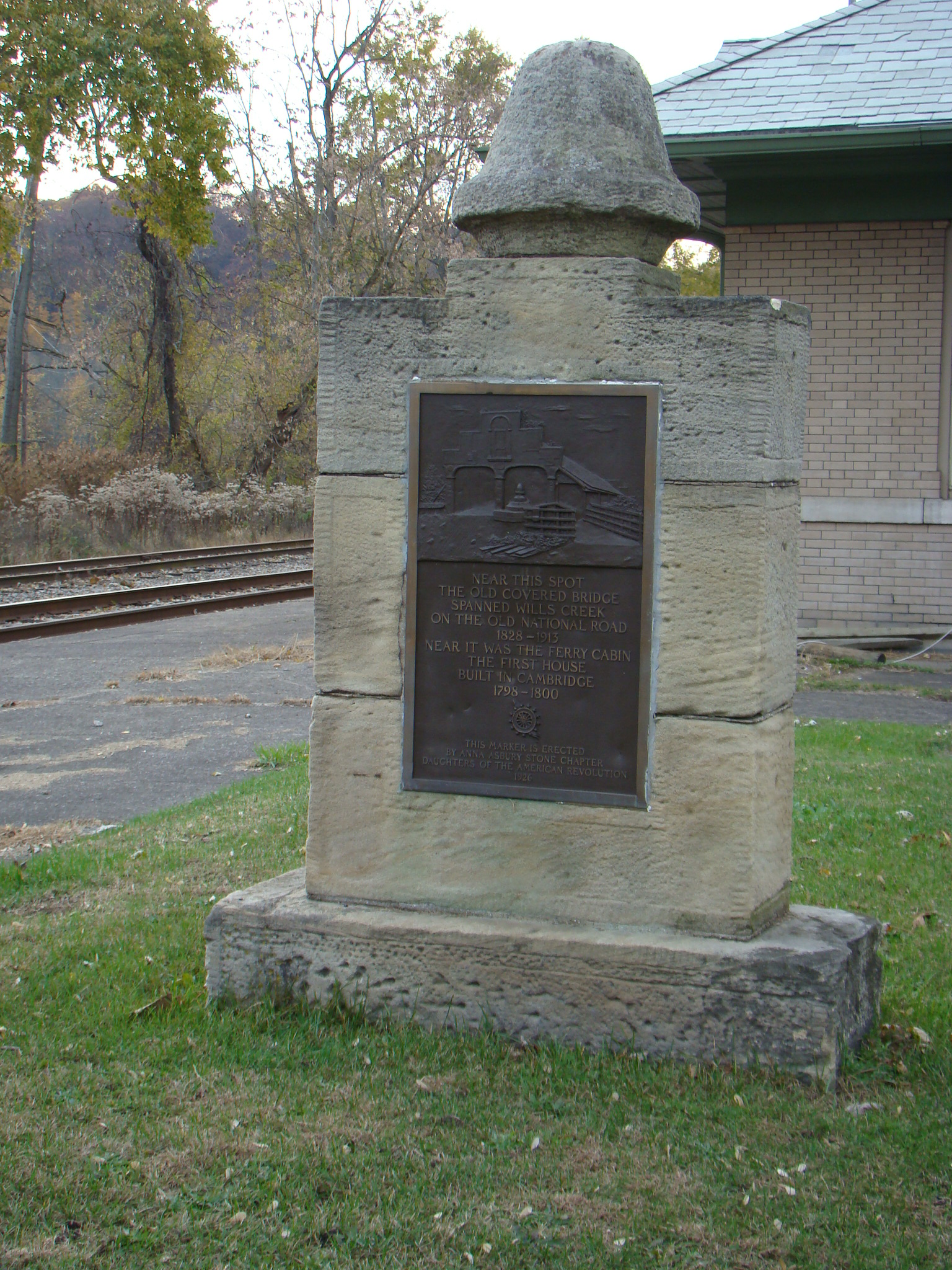
While the tracks are still active today, no stops are made at the lonesome depot. Outside the depot stands a memorial placed there in 1926 by the Daughters of the American Revolution to remind visitors of the beginnings of Cambridge. In the earliest times, crossing of Wills Creek was made by ferry, the first real business in Cambridge. Nearby, Ezra Graham established Ferry Cabin, the first house built in Cambridge back in 1798.

Double Covered Bridge over Wills Creek

Postcard view of Double Covered Bridge over Wills Creek

Crossing Wills Creek near the station, was the original Double Covered Bridge that carried people and animals down the Old National Trail from 1828-1913. That early bridge was somewhat dangerous to cross as the timbers often were displaced by floods, causing the bridge to frequently lean. Cost to cross the bridge was twelve cents. Soon nearby, a tavern and hotel were built and Cambridge got its beginnings.

Cambridge Union Station - 2014

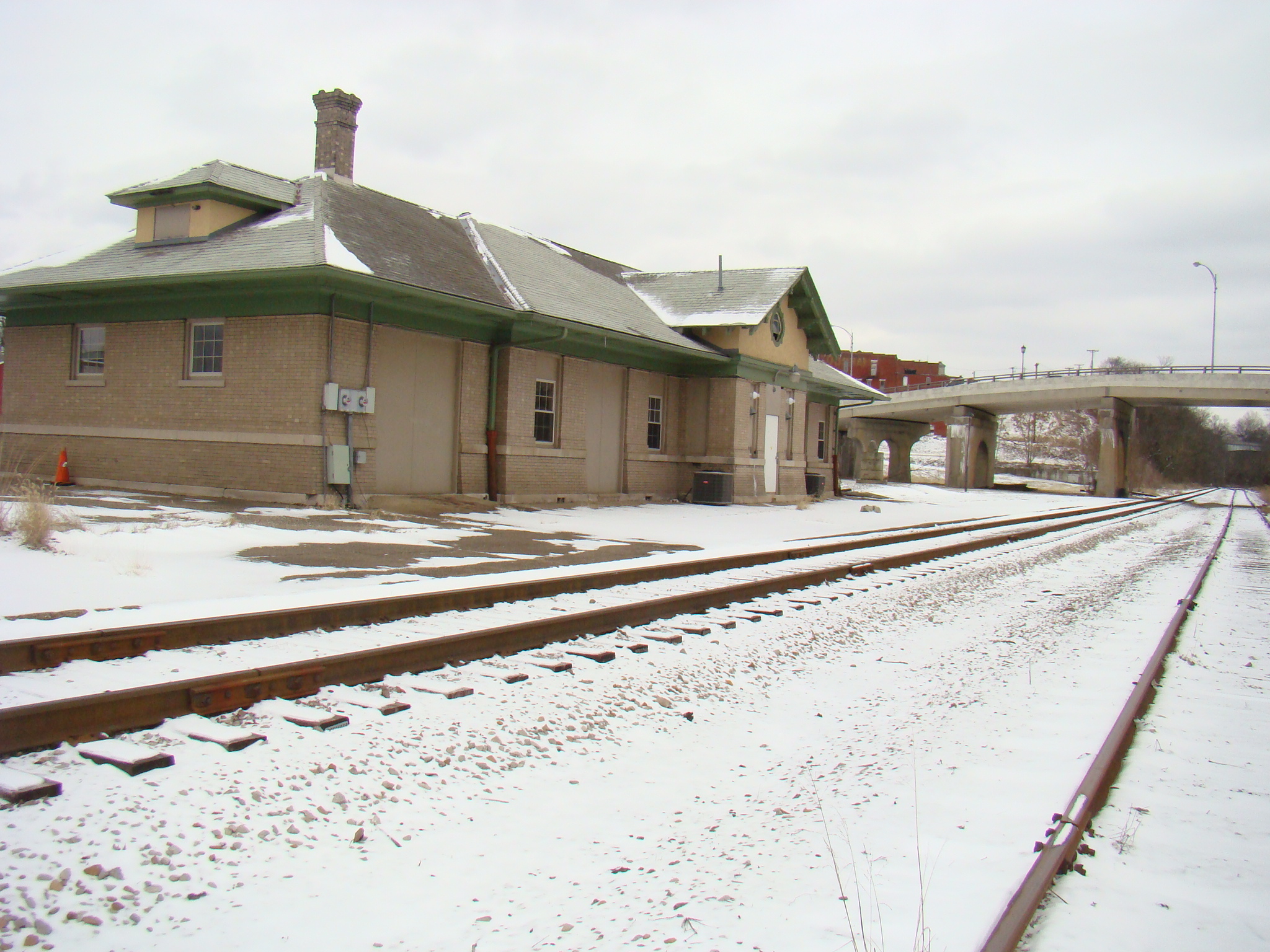
Cambridge Union Station – 2014

Union Station is still a great place to visit and feel the old memories that live there. Once in a while a train passes by so you might get a friendly wave from the engineer. As you stroll around the depot, notice the viaduct where that double covered bridge used to cross. Let your eyes wander to Wills Creek and imagine a steamboat going down those waters. Life then was certainly different than what we experience now.

Cambridge Union Station is located in Cambridge, Ohio just off Route 40, the Old National Road. It sets on the west side of the present viaduct near the corner of Wheeling Avenue and 4th Street. Since it is right along the railroad tracks, you can’t miss it!

Advertisement

Following Morgan’s Raiders Trail 150 Years Later

Sketch of Brig Gen John Hunt Morgan

Sketch of Brig Gen John Hunt Morgan

During the Civil War, 150 years ago in July of 1863, Brigadier General John Hunt Morgan led a band of scoundrels, known as Morgan’s Raiders, through Ohio on a two week expedition consisting of many raids and robberies. Their purpose was to create terror and deviate the attention of the Union troops from Confederate forces.

The Ohio Historical Society has commemorated that John Hunt Morgan Heritage Trail with 56 interpretive signs from Cincinnati to West Point in northeastern Ohio. Official dedication took place at the entry point into Ohio at Harrison in July of 2013, although planning has taken several years.

First Morgan's Trail sign in Guernsey County at Cumberland, Ohio

First Morgan’s Trail sign in Guernsey County at Cumberland, Ohio

Wanting to explore the local side of this route, my drive began in Cumberland, Ohio, which is the first place in Guernsey County, my home county, that Morgan’s Raiders appeared. Here in front of the old Cumberland High School is plaque #39, which begins the local trail of clever escapes by Morgan. Having invited themselves as dinner guests, Morgan’s men stole horses, cash, and even a guide before heading on to Point Pleasant (today’s Pleasant City).

Watch for signs like this to follow the trail easily.

Watch for signs like this to follow the trail easily. Former Pleasant City High School sits in the background.

Morgan’s Trail is well-marked with signs at frequent intervals so you can rest assured you are still on the correct route. Stories on the plaques tell about real events that happened near each marker and all contain a couple beautiful old pictures from Civil War days. Each sign also explains, in the lower left hand corner, the location of the next commemorative stop

At the corner of State Routes 313 and 285 in Senecaville, followers will find plaque #40. On July 24 at 3 am, Morgan’s men rode into the village boldly knocking on doors to find out local road information. Lucky for Morgan, Colonel William Wallace of the Ohio Infantry had received an erroneous report and hours earlier had moved from that very crossroads. Ever since the battle at Buffington Island, Brig. Gen. James Shackelford had been in hot pursuit of the Raiders and seemed to be closing the gap.

Interpretive sign #41 at Lore City trailhead.

Interpretive sign #41 at Lore City trailhead.

Campbell’s Station (today’s Lore City) had the most destruction of any place in Guernsey County with Shackelford being only seven miles behind. Located at the trailhead of the Guernsey Trail, #41 plaque area was the only one in Guernsey County that had been expanded with other information about the history of that area, as well as beautiful flowers.

At the edge of town on Old Mill Road, the battle at Washington (today’s Old Washington) is recognized. Sign #42 is near Cemetery Hill where Shackelford’s troops began firing on Morgan’s Raiders, who had spent the night in Washington. The officers had moved in, unwanted, to the American Hotel while others slept throughout the town, even in the streets. It came as a surprise that the plaque was not downtown with the 1927 monument to this skirmish.

Those four stops mark the route through Guernsey County, then the Trail guides you on toward Piedmont. By now you are beginning to get caught up in the thrill of the chase and to understand the lay of the territory they are crossing. Winding roads follow the Trail as best they possibly can, but Morgan’s Raiders attempted to travel through the woods quite often so the route is close, but can’t possibly be perfect.

Imagine the surprise and fear when up to 2000 Confederate soldiers arrived in one of these small towns along the way.  No wonder the unruly children were disciplined with the phrase: Morgan will get you!

Monument to honor Morgan's Raid erected by Carroll County Historical Society in 1868.

Monument to honor Morgan’s Raid erected by Carroll County Historical Society in 1868.

My original plan had been to follow Morgan’s Trail just through Guernsey County, but once caught up in following Morgan’s Raiders, it was impossible to stop before reaching the spot where Morgan was captured. Being led through Harrison, Monroe, Jefferson and Carroll counties, the posted signs by the Ohio Historical Society were  easy to follow.

With troop numbers diminishing at each spot, Morgan continued to use clever escape tactics as long as he could.  The Raiders might pretend to be Union soldiers, stir up dust to hide themselves, or give promises they could never fulfill.

The last few marked encounters led through rugged, gravel roads. As you slowed down on these rutted and often muddy roads, you could almost feel the weariness of the troops.

End of Trail near West Point, Ohio

End of Trail near West Point, Ohio

Finally, Morgan’s Trail, with plaque #56 entitled West End, came to an end in someone’s front yard where a monument had also been placed years ago. Morgan had tried his best to get back to cross the Ohio River and he was getting so close. Minutes later, I saw the beautiful Ohio River and felt a little sympathy for Morgan’s never reaching it.

The Heritage Trail from Cumberland to West End took Morgan’s Raiders four days from July 23 – July 26. By car, it took about eight and a half hours and I didn’t steal any horses, demand any dinners, or burn any buildings. They must have been worn out to have covered all that territory so quickly on horseback.

Even though he was captured for the moment, his cleverness helped him escape prison and travel unknowingly with a Union soldier on a train back home. Despite the chaos and destruction left behind, he taught the importance of never giving up in your quest to reach a goal.

Will Mount St Helens Erupt Again?

Earthquakes! Steam explosions! Molten lava!  All of these were present during the 1980 awakening and subsequent eruption of Mount St Helens in Washington. Today this area, home of the largest volcanic landslide in recorded history, is designated as Mount St Helens National Volcanic Monument as a place for research, recreation and education.

Johnston Ridge Observatory, just one of the visitors’ centers, was a great place to start exploring. Their theater showed great footage of the 1980 eruption. Here you also found first hand accounts of individuals who were actually in the vicinity that day. Of particular interest were the machines that recorded the seismic activity presently occurring.

There were several trails leading up the side of Mount St Helens, which appeared mostly barren being covered with ashes. You could walk among the fallen trees that were flattened by the blast. If you felt braver and went a little farther, you could even see vehicles and heavy logging equipment that was damaged when Mount St Helens blew her top. Took the path as far as was permitted at that time. The hiking trails stay open according to the mood of the volcano.  When she is steaming or spewing forth lava, they obviously need to be closed. But what a thrill to get as close as possible to the top of Mount St Helens.

The 1980 eruption left behind a trail that is still visible today. Due to the force of rocks and ice, trees in the lava path were struck down like bowling pins.  Today they still lay there on the ground but the forestry department has gradually handplanted new seedlings amongst the fallen trees.

From 1986 – 2004, the mountain slumbered until in 2004 earthquakes rippled through the earth. Later that year a smaller eruption began and about a dump truck load of lava oozed out of Mount St Helens every second thus slowly rebuilding the mountain.  By 2011 the amount of lava oozing from the mountain was reduced to a dump truck load every fifteen seconds.  If the eruptions would continue at their present rate, the mountain would be back to its original height in about 180 years.

During the 1980 blast, everything within miles was covered with ash from the volcano.  So suppose it was easy for the ash to be gathered and sold as souvenirs.  Still have a pen said to contain ash from that volcanic eruption.The entire landscape has changed from that 1980 blast. New river routes have been formed and even new lakes. Here you see a real change of scenery due to the awesome power of nature.  Will a major eruption happen again? Probably not in our life time, as most volcanoes erupt every 100-300 years.  The future holds hope for reforestation and rebuilding…unless another eruption occurs sooner than expected.

Hope your life will erupt with much happiness, and may you spread that happiness for miles around.

Mount St Helens National Volcanic Monument is located in Washington approximately 96 miles south of Seattle, Washington and 50 miles northeast of Portland, Oregon. One easy access route is from I-5, Exit 68 onto the Spirit Lake Memorial Highway/ WA 504. This route passes through the various visitors’ centers and into the center of the original blast zone.  

Amazing Scenery Along the Pacific Coast Highway

The surprises kept coming on the beautiful Pacific Coast Highway, which began in Washington and continued along the edge of the Pacific Ocean through Oregon and California, stopping at San Diego. Meandering roads kept driving speeds at 15-20 mph, or perhaps it was partly due to the spectacular views. When driving and watching the scenery at the same time, slower speeds were definitely required especially with many steep cliffs at the ocean’s edge.

With beaches galore and piers aplenty, Pacific Coast Highway, also known as America’s Most Beautiful Drive, renewed your spirit and your senses, as you encountered many unusual scenes along the way. This curving highway passed right  through the awesome giant redwoods on a stretch called Avenue of the Giants.This was the place where trees were large enough for a car to drive through or even have a gift shop inside. Words can not describe the wonder of these giants as you attempted  to look skyward  to see their highest branches. These towering trees, rock formations and ocean waves made you realize the power of Mother Nature and the role she plays in our beautiful world.

Even on a foggy morning, the picturesque combination of mountainous cliffs  on one side, and the waves crashing against the rocks on the other, made your heart beat just a little faster. After spotting a sign that said Pebble Beach Golf Links, thought the golfers in my family would be happy to know I stopped for a visit, as this is home to some of the world’s most prestigious golf tournaments.  Evidently it was a day without a tournament scheduled, as admission was granted to drive up to the luxurious lodge and even to walk on the course. My camera definitely wanted to snap a picture of the famous 18th green to prove my story wasn’t fiction.

Near Big Sur the mountains seemed to plunge into the Pacific. Unusual black rock formations rose out of the water to create amazing and different views around each bend of the road.  . These towering black rocks made a sharp contrast against the constant waves of the Pacific and the blue sky. Surfers in their wetsuits rode the waves and kayaks bounced across the ocean. A couple young men enjoyed hang gliding and the winds must have been perfect that day as they were airborne  for a very long time.  Might have to try that on another trip to experience the sensation of flying! Everywhere you felt the happiness of people relaxing from the cares of the day.

There was no resisting the temptation to find a place to pull off the road and walk on the beaches. Leave your shoes behind so you can feel the power of the waves wash over your feet. Two golden labs approached with a frisbee in their mouth so ended up the day playing catch with the labs.  Memories of the ocean will live on, long after the footprints in the sand are gone.

The Pacific Coast Highway, Highway 1, begins in Oxnard, Washington and continues along the coast through Oregon into California all the way to San Diego. Sometimes Highway 101 bends inland so watch carefully if you want to enjoy the scenic journey along the coastal region.

Tag Cloud