Places to go and things to see by Gypsy Bev

Archive for April, 2020

National Coal Company Located in Dogtown in 1906

Miners crossed this old wooden bridge to work at  Minnehaha Coal Mine.

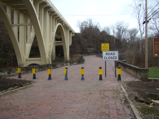
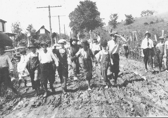
Workers used this old wooden bridge to cross from Buckeyeville to work in the Minnehaha coal mine.

Minnehaha isn’t a name most of us associate with the coal mines of Guernsey County. But the truth of the matter is there was a mine by that name back in 1906 located near what is today called Buckeyeville, or more commonly Dogtown.

     National Coal Company from Cleveland had heard of the success of the Byesville coal mines. They decided to purchase hundreds of acres and lease even more west of Byesville in an area that had no name. Their first concern was the lack of a railroad to the area.

Children - Main Street looking east

This group of children in Buckeyeville appears to be happy and they look neat and clean.

     So the company paid Pennsylvania Railroad to install a track from Byesville to the new mine. This included building three bridges to cross Chapman Run. National Coal Company felt that the Pennsylvania Railroad was charging them too much by increasing the number of crossties that were actually laid.

     They sent out a man to count the crossties. The man started the five-mile walk counting each crosstie but stumbled and lost count along the way. Not wanting to start over, he returned to National Coal Company telling them that Pennsylvania Railroad had actually laid more crossties than they were paid for. His secret was not known for sixty years.

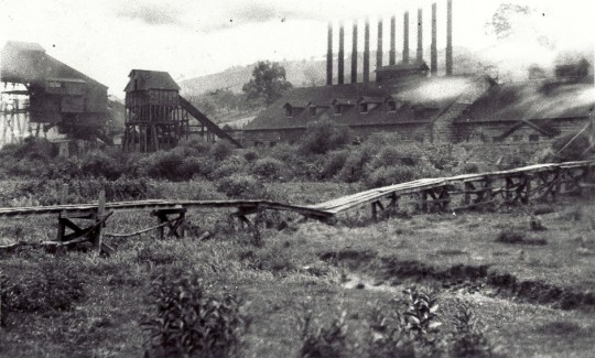
     Once the railroad was completed, they began bringing all the new equipment into the site including a steel tipple, generators, a coal cutter, coal cars, and an electric locomotive. A wide slope opened down to the coal seam at Minnehaha.

Water tubs for 10 boilers. Need lots of water

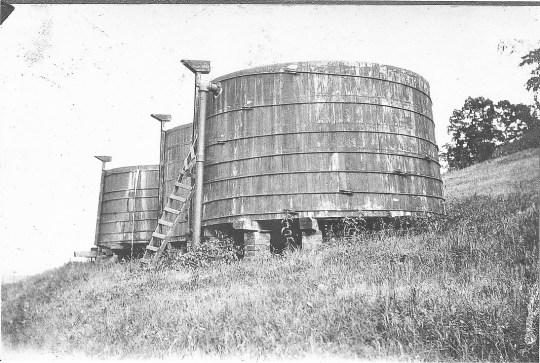
These water tubs supplied ten boilers, which needed plenty of water to operate.

     When that mine opened in 1906, it was a very busy place. There were four boilers that made steam to turn two generators which created 250 watts of power. This was not to be used by the homes but to run the coal cutting machines and electric locomotives. The town nearby would not receive electricity until the 1930s long after the mine was closed.

rear of store in Buckeyeville

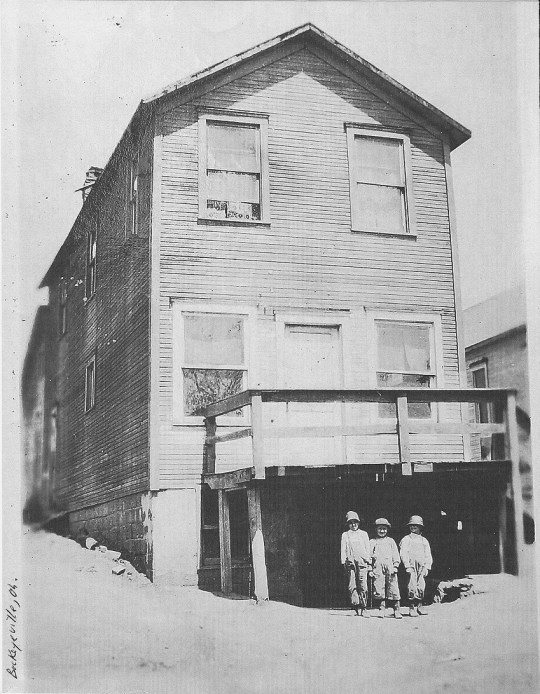
Children stand at the rear of the company store in Buckeyeville.

     Shortly after 1910, they began building houses in what is today Buckeyeville. By the time the mine closed, there were approximately forty houses in Buckeyeville as well as a company store, church, and school. There was no electricity or running water in the houses and rent was due the first of each month. The company store did have electricity!

Ad for Coal

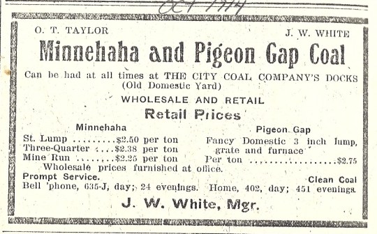
This 1914 ad listed coal prices by the ton for retail rates. Check out their phone numbers!

     With a coal seam seven-foot deep in places, at its peak, 320 miners and 80 day workers worked the mine. During a good year, 500,000 tons of coal would be mined at Minnehaha in spite of the fact that in the summer months miners worked only a few days a week.

shop locomotive - ash and supplies to boiler room

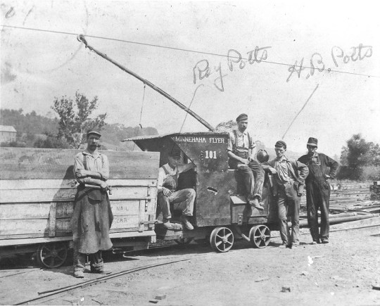
This shop locomotive carried ash and supplies to the mine. Notice the electric wires.

     National Coal Company now had three mines in the area – Minnehaha, Little Kate Number Two, and Harryette. To provide electricity to all three mines they built the largest power plant in Guernsey County with ten boilers at Minnehaha.

     Eventually, there were nine mines open along the railroad to Byesville. These nine produced a daily output of 100 railroad cars of coal. These cars held between 50 and 75 tons each. Train crews said they were working “the Dogtown switch.” Why was it called Dogtown?

Kids parade on Main St. 19l17

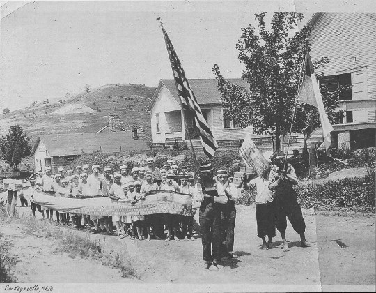
These children of miners are having a parade in 1917.

     Beside the deep mines, there was a vein of coal that was not nearly as deep. Families sometimes dug into the hillsides in what was called a “scratch back mine” to get coal for their own use. Imagine working in the mine all day and then going home to dig your own coal out of the hillside.

     When they tried to pull this out of the hillside in small carts there wasn’t much room. It was found that dogs could do this task quite well so families raised dogs for work in the mines. Most of the time these dogs ran loose along the railroad tracks which is why the train crews named it Dogtown. Somehow the name stuck and many people still call it Dogtown today.

Union Hall Local #63 (1912) - Rev. Nathan Cramblett held church services

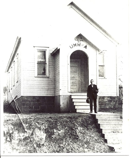
Rev. Nathan Cramblett held church services for miners in the Union Hall of Local #63.

     There was never a doctor in this area so injuries were not properly treated. Ten men died in Minnehaha. But that doesn’t account for the fact that many had injuries that maimed them for life. Fingers, hands, and feet were lost, broken bones ruined many miners’ backs, and black lung became a curse for most who labored in the mines. This was the most dangerous job in the world.

     Coal miners worked hard as they had to load all of the coal by hand using a pick and shovel. They had no vacations and were paid by the ton of clean coal that was loaded. Coal miners always worked on a buddy system for safety reasons. So that meant that when a ton of coal was loaded, that fifty cents had to be split between them. In reality, that meant twenty-five cents for each ton loaded. All of this for a two weeks pay of $15 or $16.

Blacksmith Shop

This blacksmith shop stood near the main road down to the mine.

     All of their supplies had to be purchased at the company store, which was one of the first things they built. Hard to realize that the miners had to purchase their own tools, props, and wedges.

     If you have heard stories of why this mine was called Minnehaha, please let me know. The name seems a bit of a mystery although it is a Dakota Indian name. Its Indian meaning translates as “rapid water” or “waterfall.” There was no rapid water or waterfall within thirty miles of the mine location.

1934 photo of Buckeyeville. Old wood bridge miners would use to go home from work.

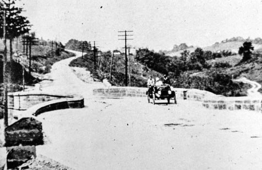
This is a 1934 picture of Buckeyeville after the mine was closed. The bridge to work can still be seen.

     Minnehaha was shut down in 1928 after much of the coal was removed. The company found that they could find cheaper labor in Kentucky or West Virginia so when their lease was up, they moved to another coal mining area. While miners here were receiving fifty cents a ton for coal at that time, the miners in the other states were willing to work for about half that amount.

Dogtown Today

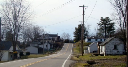
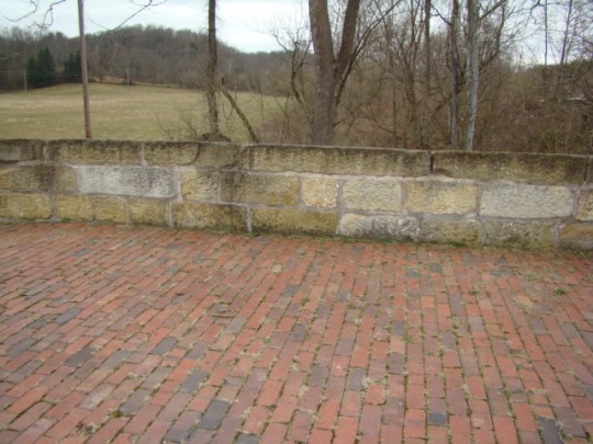
Today, Buckeyeville still exists as a small, friendly, unincorporated village.

     Never again would trains remove coal from a town that we now know as Buckeyeville or “Dogtown.”

Thanks to Dave Adair for providing information and pictures for this article.

Advertisement

Impressive Flag Show By Vane Scott in Sarasota, Florida

Vane at Patriot Plaza

Vane Scott had an attentive crowd at Patriot Plaza in Sarasota, Florida.

This concert was presented before the recent social distancing was put in place.

     The 2,800-seat outdoor amphitheater at Patriot Plaza in Sarasota, Florida was recently filled to capacity for Vane Scott’s presentation of “The Many Faces of Old Glory.” The event was sponsored by the Sarasota Military Officers Foundation so American patriots could learn more about the history of the flag of the United States.

Vane - The Pops Orchestra of Bradenton and Sarasota (2)

The Pops Orchestra of Bradenton and Sarasota provided background music.

     This was a repeat performance for Vane Scott as he had previously performed there in 2015 with the backing of the Pops Orchestra of Bradenton and Sarasota, who again provided background music for this year’s flag show. When someone is asked back for a repeat performance, it’s obvious that the show has been appreciated.

vanes-dad-with-flags

Surrounded by the many flags used in the performance, Vane’s dad started this flag show.

     Vane credits his dad with starting the flag show back in 1975. Of course, Vane went along to many of those shows and his passion for the story grew. His dad encouraged Vane to learn the story of the flag and they even practiced at the kitchen table when his father became ill.

    Soon afterward, he decided to carry on the family tradition.“I needed to tell Dad’s story.” Vane would tell you today, “Dad’s with me every time I do his show. It’s been nine years since he passed away. I miss him terribly.”

Vane Show Crowd

A capacity crowd filled the stadium to hear the history of our flag.

     When he was introduced, he told the crowd, “I’m from Newcomerstown, Ohio along with a couple of famous people you might remember. The baseball pitcher, Cy Young, grew up in our area and Ohio State’s football coach, Woody Hayes went to school there.”

     He then delighted the crowd of Floridians, many with Ohio roots, by raising his arms and saying, “O-H”. To which nearly 2000 voices responded, “I-O.” The evening was off to a great start!

Vane - Many Faces of Old Glory

Vane tells the story as he shares the Bennington Flag from the American Revolution.

     “The Many Faces of Old Glory” contains the story of the many steps taken before we arrived at the United States flag we know today. Vane has over twenty different flags that help him tell the story. Some are odd, strange and downright crazy looking so there is humor laced with the history to make the show entertaining as well as informative.

Vane and Miss Tampa

Miss Tampa Lauren Nielsen provided patriotic vocal selections.

     Vane was honored and pleased to have Miss Tampa Lauren Nielsen as his backup singer. She sang “The Star Spangled Banner” as well as “God Bless America.” Vane remarked, “She has an amazing voice and range. She hit those high notes perfectly.”

     He still uses the same flags his father left folded up nine years ago. His goal is to help others understand the country’s rich heritage and give us a reason for being proud of our country.

Vane Scott

Vane is always ready to tell “The Many Faces of Old Glory”.

     While Vane is back home now, he’s always willing to present his flag show when the opportunity presents itself. Perhaps when things settle down in our country, your group might like to contact Vane Scott for a performance of “The Many Faces of Old Glory.”

    Contact Vane at 740-498-8803 or email him at vanescott@yahoo.com. Visit his website at www.ManyFacesofOldGlory.com

      Vane always reminds the crowd, “We may be born in America, but to be an American is quite another thing.”

National Road S-Bridges Preserved

Middlebourne Bridge 1903

Salt Fork Creek S-Bridge 1903

     Follow the trail those early pioneers took from the Ohio River to beyond New Concord and visit four S-Bridges and two stone bridges along Route 40. While you can no longer drive on any of these S-Bridges, you can walk on their bricks and think back to the difficult times those early pioneers must have faced as they headed to Ohio and westward.

S Brick Road and Stone Walls

Brick road and stone walls at Peter’s Creek

     “The Main Street of America” began as a dirt road. Next, they tried logs and many called it a Corduroy Road, but it was very rough. Crushed stone was added called macadam and finally, much of it was paved with bricks.

S Bridge diorama in Zane Grey Museum

National Road bridge diorama at National Road/Zane Grey Museum 

      The National Road was one of the first paved roads across the state of Ohio. While it began in Cumberland, Maryland in 1817, it wasn’t until 1825 that the road was built across Ohio until it reached Vandalia, Illinois in 1838. Stagecoaches and Conestoga wagons were the two most common ways of travel, but many rode horseback or walked.

     There are many reasons people say they built the S shape. Some claim it was to stop runaway horses, to go around trees or even that the builders were inebriated. The reason was simply an engineering decision.


S Bridge sign at Middlebourne

1938 sign on Salt Fork Creek Bridge: In memory of the pioneer who built this “S” bridge.

    Where the road crossed a creek at an angle, a stone arch bridge was built at right angles to the streamflow. “S” shaped walls of cut stone were then built to direct traffic around the jog and back into line with the road on the other side. It also made work easier for the workers as they worked from each side of the creek. The brick roadway made the bridge extra durable.

     Here is a short description of the location of each of those S-Bridges and stone bridges along the National Road in the order of their appearance from east to west.

S Blaine Hill and Viaduct

Blaine Hill S-Bridge and Viaduct

     Blaine Hill S-Bridge – Crossing Wheeling Creek near Blaine, Ohio, its three stone arches span approximately 345 feet, the longest crossing of any bridge at that time with a 6.3% grade. This eased the climb out of the valley and was a marvel of engineering. All the original precisely cut stones are there today.

S Salt Fork

Salt Fork Creek S-Bridge

     Salt Fork S-Bridge – Just east of Old Washington, you can find a well-preserved S-Bridge, which was near the town of Easton. The bridge is built of randomly laid stone giving it a road width of 26 feet. It was closed as recently as 2013.

S Bridge Cooks Run

Cooks Run Stone Bridge

     Cooks Run Stone Bridge – Only remnants remain of this abandoned stone bridge. When a new bridge was built over Cooks Run, the remains of the old bridge were left underneath. It can be seen about 500 feet off Route 40 about 2 miles east of Cambridge on the north side of the road.

Crooked Creek Stone Bridge

Crooked Creek Stone Bridge

     Crooked Creek Stone Bridge – On Manila Road, you can still drive over this Crooked Creek bridge. This is south of Route 40 on the other side of the railroad tracks across from the patrol barracks. While the entrance to the bridge has a large curve, the bridge itself is not s-shaped.

S Peters Creek

Peter’s Creek S-Bridge

      Peter’s Creek S-Bridge- This is one of those bridges that many of us pass quite often on the north side of Route 40 near Pike School at Peter’s Creek Road. There is a small park area to have a picnic or just relax.

S New Concord

Fox Run S-Bridge

     Fox Run S-Bridge – On the west side of New Concord, this bridge has been restored and a small area made into a parking and picnic area. My sons fondly remember going here with their grandfather to enjoy an ice cream treat from the New Concord ice cream stand.

DSC04532

Historic signs can be found at the S-Bridges.

     Four of these bridges have been found worthy of restoration to preserve the history of our ancestors while others have disappeared. This road was the only link between the east coast and the western frontier during the 19th century. There were four tollhouses in Guernsey County to help with the great expense of building this highway. Congress spent almost $7 million building this 620-mile road.

     In 1832 a sample of tolls was listed as:

Score of sheep or hogs……$.05

Score of cattle……………….$.10

Horse and rider………………$.04

Sulky drawn by one horse.$.08

Chariot or coach…………….$ .12 1/2

S Wheeling Creek

Blaine S-Bridge over Wheeling Creek

     Take a historic ride along Route 40 in Ohio starting at Blaine, where you can see the history of the developing highway that Abraham Lincoln traveled on trips from Illinois to Washington, D.C. Beside the Blaine S-Bridge is the BlaineViaduct which was built when the S-Bridge could no longer handle all the auto traffic. Just a short distance to the south you will find today’s I-70. From the S-Bridge, you can clearly see the three generations of our national highway system.

     Move on to Old Washington and end east of New Concord to view the route of those early pioneers. Imagine the wagons loaded with goods and crops as they traveled the Old National Trail. Perhaps you would have enjoyed being on the road at that time or maybe you would prefer the comfort of today’s travel.

Tag Cloud