Alan Cottrill’s Sculpture Studio & Gallery is watched over by Chief Nemacolin, an American Indian who helped blaze the National Road through Pennsylvania.
Often in life, people return to their hometown area for various reasons. Alan Cottrill came back to Zanesville, Ohio in 2003 to open a Sculpture Studio & Gallery at 110 South 6th Street. Here he found the perfect spot for his artistic designs in the former Zanesville News building, where the words from Michelangelo hang on his wall.

Alan tells about all the busts he made during his first two years of sculpting.
Like many young people from a poor background on the farm, where his dad was a Meadow Gold milkman, Cottrill explored several careers during his lifetime. As a youngster, he never seemed to run out of ideas or job opportunities. In high school, he sold candy bars at lunchtime, worked as a guard, supervised Y-City umpires, and helped at the Skyway Drive-In.
After trying the college scene, the army, and being a milkman himself, he founded the Four Star Pizza franchise with his dad, and became an international entrepreneur. As he traveled the world, art museums attracted his attention and he began collecting art and paintings – his first being in Bulgaria.

Alan holds his Sculptor’s Bible, an old anatomy book.
Then in 1990 in California, PA, Cottrill touched clay for the first time, realizing his intense passion for creating. He sold his business and devoted himself full-time to becoming the finest figurative sculptor in the world. His studies at the Art Students League and National Academy of Design in New York City developed his abilities.
Cottrill sculpted a brass plaque of the McIntire Library in Zanesville, because he said it opened the world to him. His love of books continues to this day. His Sculptor’s Bible is a well-worn book on anatomy, as he feels the need for accuracy in all of his creations, which display intricate design but most importantly, emotion.
Outside his studio, statues line the street making it a treat to drive past his gallery, but it also gives a desire to know what’s inside. His working studio is on the ground floor, with the gallery above. The bronze sculptures demonstrate his passion and curiosity to always be looking for something new. He feels, “The degree of passion in artwork shows the degree of passion one has within.”

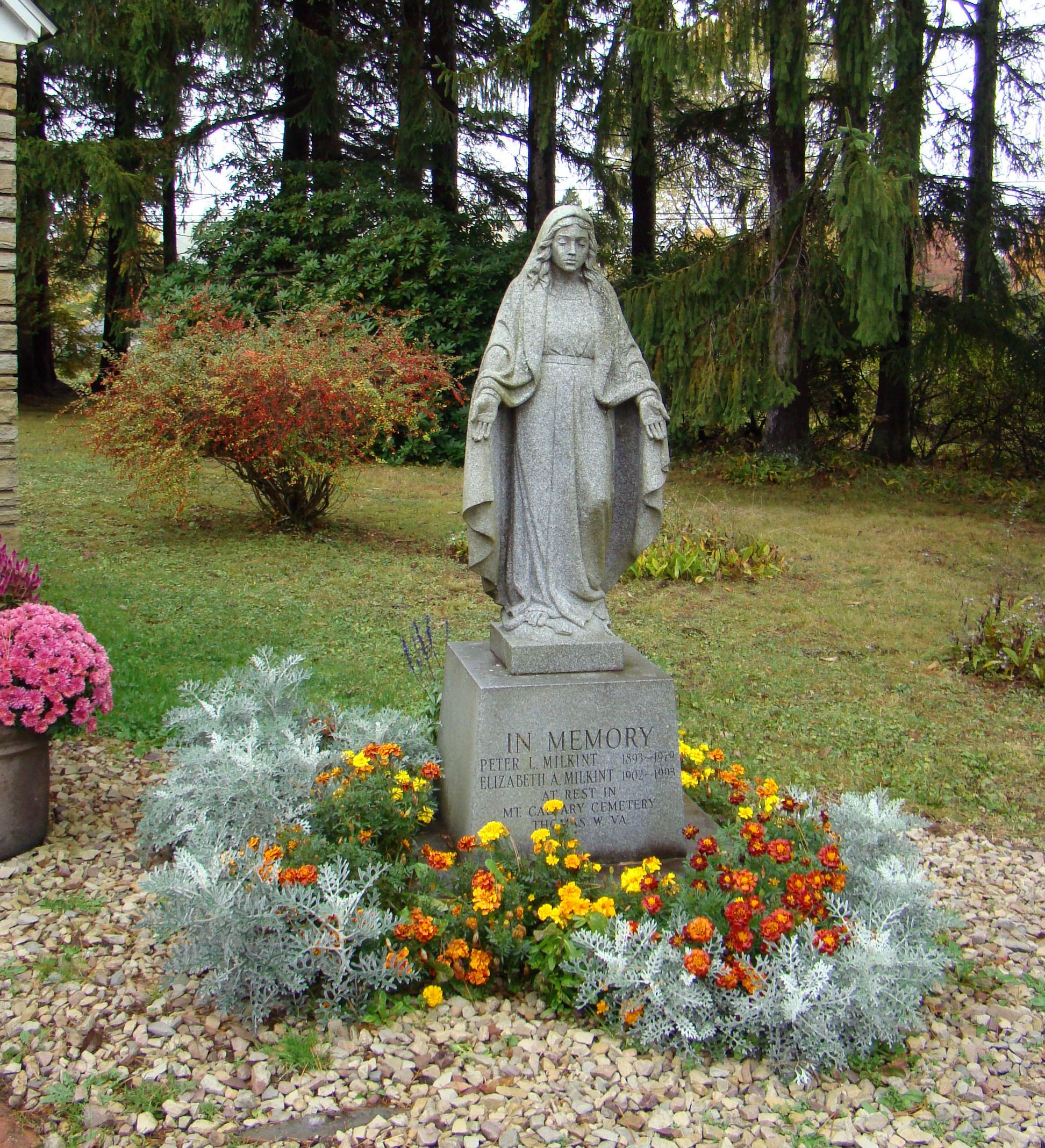
Alan checks his favorite sculpture – tombstones for him and his wife.
Once Cottrill receives an inspiration or a consignment, he then assembles photographs of objects, researches clothing and accessories, and then begins the formation of a clay bust, where he makes the face come to life with emotion. The clay he uses comes from Laguna Clay in nearby Byesville, Ohio.
In order to have quality bronze available, Cottrill, along with his lifelong friend, Charles Leasure, established Coopermill Bronzeworks, Ltd. All of his pieces are bronzed there and they also do work for other artists.
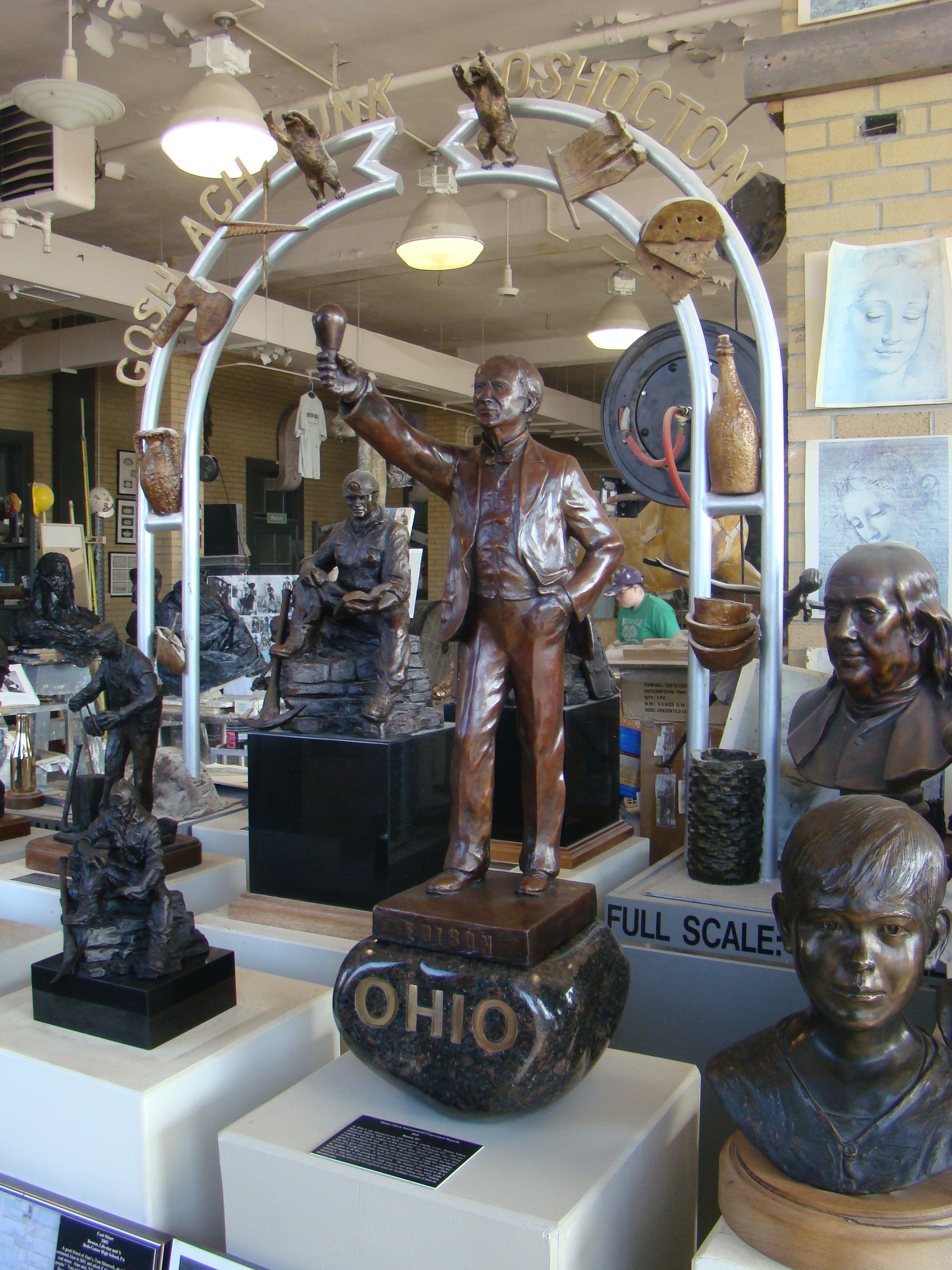
Thomas Edison Bronze Sculpture will soon be placed in U.S. Capitol to represent Ohio.
Over 400 bronze sculptures are displayed in his Zanesville studio. They range in size from 18 inches to lifesize, which takes about seven weeks to complete. While his favorite piece of work is the tomb sculpture he did for him and his wife, the one that receives the most attention is his Woody Hayes bronzework, which appears in front of the Woody Hayes Center at OSU in Columbus, Ohio.

Bronze Ohio Coal Miners Statue stands at the old railroad station in Byesville.
In nearby Byesville, he sculpted the Ohio Coal Miners Statue, paid for by contributions from those who rode the train over a several year span. His Thomas Edison statue has recently been accepted for the U.S. Capitol; while for Cambridge, Ohio, the Hopalong Cassidy bronze statue is only just begun.
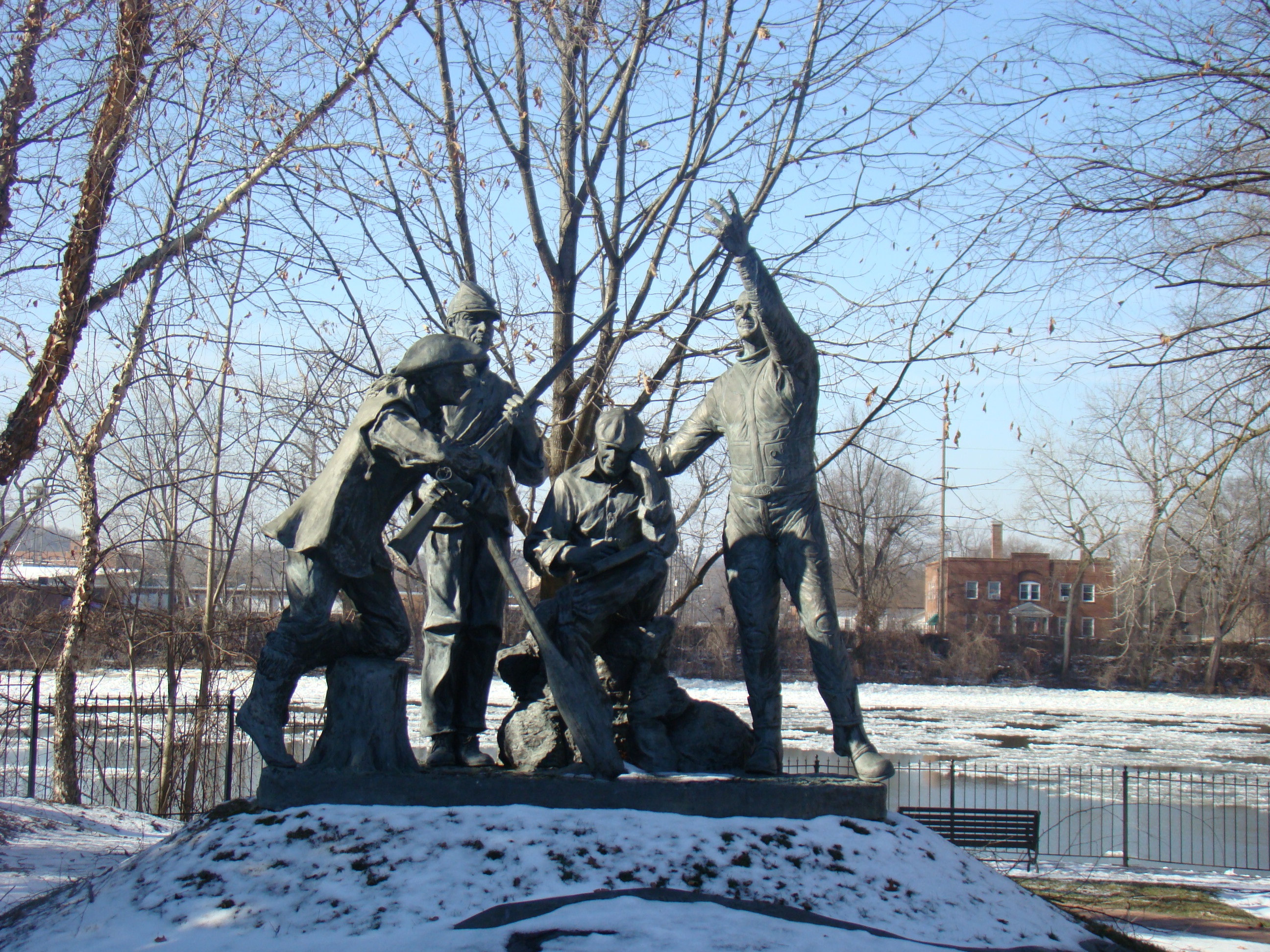
Bicentennial Legacy Monument stands on a mound at Zane’s Landing on the Muskingum River.
Watch Alan Cottrill at work in his studio in Zanesville, Ohio, where you will find the world’s largest bronze sculpture collection of any living sculptor. If you are lucky, he will share stories of his life and his passion. This amazing sculptor still works seven days a week…but doesn’t start as early anymore!
To discover Alan Cottrill Sculpture Studio, take I-70 exit 155. Drive south a half-mile. Turn right onto Marietta St., then right again onto S. 6th St. The studio is one block ahead on the right. Look for the statues lining the street.